The Central-West Region of Brazil, since its colonization in the first half of the last century, has undergone a process of occupation that resulted in a highly concentrated land structure. Its economy, after the initial period in which mining played an important role in some areas, was mainly based on livestock and agriculture.
It is possible to observe different patterns in the occupation of different areas of the Center-West, influenced by enterprises focused on grain farming and livestock, with the application of advanced technology, as well as by the proximity to the Southeast Region.
The Central-West Region of Brazil is an area of great environmental importance due to the presence of the Pantanal, Cerrado and Amazon biomes. These biomes face significant environmental preservation challenges due to the continuous stimulus for economic development, mainly through agricultural activity.
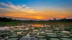
Wetlands, including the Pantanal – with its largest territory between the states of Mato Grosso and Mato Grosso do Sul, covering areas in Bolivia and Paraguay – perform important environmental services, including water storage and purification, sediment retention, climate regulation and maintenance of biodiversity.
Although the Pantanal Biome has specific legal protection, with recognition as a National Heritage Site by the Federal Constitution of 1988 and as a World Heritage Site and Biosphere Reserve by the United Nations, it still suffers impacts from agricultural activities. The new Forest Code establishes conditions for ecologically sustainable exploitation and suppression of native vegetation in these areas. However, this legislation reduced protection for wetlands by defining the bed of the river's regular channel as a parameter for measuring APPs (Permanent Preservation Area), reducing the scope of protection.
The reduction in water surface is a direct result of human actions, which affect the climate and the environment. Floods are essential for the balance of the biome, and the decrease in the amount of water is linked to climate issues, such as more intense droughts, in addition to increased deforestation, especially in riparian forests close to rivers, which contributes to siltation and sedimentation of rivers.
In the past, the Pantanal used to be flooded for around six months a year, but in recent years, this flooding period has been reduced to just two months. This drastic change directly affects the fauna, flora and ecosystems of the Pantanal, which depend on seasonal flooding for their proper functioning.
The Cerrado Biome, although present in other regions of the country besides the Central-West, is considered a global area of biodiversity. Only 7,44% of its area is protected by conservation units. Deforestation in the Cerrado has been alarming, with annual rates higher than other Brazilian biomes. This Biome covers an extensive area of approximately 25% of the national territory. It extends over approximately 1.8 to 2 million square kilometers, reaching several states, such as Goiás, Tocantins, Mato Grosso do Sul, Mato Grosso, Minas Gerais, Distrito Federal, Bahia, Maranhão, Piauí and parts of São Paulo.
The Amazon Biome, which occupies around 50% of the national territory, covers some municipalities in the state of Mato Grosso in the Central-West Region. It occupies an area of 4,196,943 km², which corresponds to more than 40% of the national territory and consists mainly of tropical forest.
The Amazon passes through the territories of Acre, Amapá, Amazonas, Pará and Roraima, and part of the territory of Maranhão, Mato Grosso, Rondônia and Tocantins. It is made up of different ecosystems such as dense dryland forests, seasonal forests, igapó forests, flooded fields, floodplains, savannas, mountainous refuges and pioneer formations. Even though our biome is the most preserved, around 16% of its area has already been devastated, which is equivalent to two and a half times the area of the state of São Paulo.
The preservation of the Central-West Region and its biomes guarantees the survival of the species and ecosystems present, contributing to the maintenance of ecosystem services essential for the quality of life of local populations, and for the health of the planet as a whole.
The Importance of the Pantanal: Preserving the Cradle of Brazilian Biodiversity
Conserving the Pantanal means thinking about the Basin as a whole. The Pantanal, known for its uniqueness and sensitivity, is much more than a simple floodplain. Located in the center of the Upper Paraguay hydrographic basin, it is a geographic region surrounded by the basin's plateaus, with altitudes ranging from 80 to 150 meters. However, to truly understand the importance and conservation of the Pantanal, it is essential to consider the river basin as a whole, after all, everything in this region is interconnected.
The Pantanal river basin is transboundary and covers an area of 624,320 km², approximately 62% in Brazil, 20% in Bolivia and 18% in Paraguay. This vast expanse of territory is home to hydrological resources that are crucial for supplying several cities, where around three million people live. Therefore, the conservation of the Pantanal goes beyond the preservation of a single biome, extending to the protection of the entire river basin and the ecosystem services it offers.
The ecological processes and environmental balance of the Pantanal are strongly influenced by events that occur in the upper parts of the river basin. The water that rises in these higher areas flows to the floodplain, carrying with it sediments, nutrients and all biological diversity. This “pulse of the waters” is the rhythm that dictates life in the Pantanal – a dynamic, complex and delicate cycle.
The protection of springs, rivers and areas adjacent to the plain is essential to maintain the integrity of this ecosystem. Deforestation, pollution and inappropriate land use in these high areas can have devastating consequences for the Pantanal. The silting of rivers, the reduction in water flow and the degradation of habitats compromise the health of this very special biome and directly affect the fauna, flora and human communities that depend on natural resources.
The richness and biological diversity of the Pantanal are impressive, housing a vast number of species in its ecosystems. It is estimated that there are at least 4,700 species in the region, including 3,500 species of plants, 650 species of birds, 124 species of mammals, 80 species of reptiles, 60 species of amphibians and 260 species of freshwater fish. However, many of these species are threatened with extinction, highlighting the importance of preserving the Pantanal.
The Pantanal biome has a significant area in Brazil, with the Pantanal Plain accounting for approximately 151,000 km². Furthermore, the Upper Paraguay Basin Plateau (BAP) covers approximately 217,000 km² in the country. Combining the area of the plain and the plateau, the Brazilian Pantanal totals approximately 368,000 km².
However, when we consider it in its entirety, including the areas of Brazil, Bolivia and Paraguay, the Pantanal Plain reaches 195,000 km². Furthermore, when adding the plain and the plateau, that is, the BAP as a whole in the three countries, the Pantanal reaches an impressive extension of 610,000 km².
These significant numbers demonstrate the importance and magnitude of the Pantanal as one of the most relevant biomes in terms of biodiversity in South America and the world. Its wetlands are essential habitats for a wide variety of species, many of which are endemic and found only in this region.
The Pantanal faced one of the worst environmental crises in its history in 2020, with a series of devastating fires that affected its fauna and flora in an alarming way. A study conducted by researchers from 14 institutions revealed worrying data about the impact of these fires on the fauna of the Pantanal, indicating that almost 17 million vertebrate animals lost their lives during this period.
The study highlighted that the animals most frequently found among fire victims were groups of small snakes, birds and rodents, as well as lizards, artiodactyls (for example, deer and tapirs) and primates. This massive loss of animal life represents a serious threat to the biological diversity and ecosystems of the Pantanal.
Snakes, birds and rodents play fundamental roles in Pantanal ecosystems, such as regulating insect populations and seed dispersal. The loss of these species affects the ecological dynamics of the biome, compromising its resilience and ability to recover.
Furthermore, lizards, artiodactyls and primates are considered key species, playing crucial ecological roles in maintaining the ecological balance of the Pantanal. The reduction of their populations has significant impacts on food chains and interaction processes between species.
The fires in the Pantanal not only claimed millions of animal lives, but also caused irreparable damage to the natural habitats and breeding areas of these species. The fire destroyed vegetation, reduced sources of food and shelter, and fragmented habitats, making it difficult for affected populations to survive and recover.
Updated data from the year 2023, on the accumulated deforestation in the Pantanal, reveal a worrying reality for the preservation of this important biome. The most recent figures show that two Brazilian states are responsible for most of the deforestation that occurred in the region.
The state of Mato Grosso do Sul leads this sad ranking, with a total of 10,797.03 km² of deforested area, which corresponds to around 71.73% of accumulated deforestation in the Pantanal. These numbers are alarming and require immediate action to reverse this trend and ensure the conservation of this valuable ecosystem.
In second place is the state of Mato Grosso, with 4,255.76 km² of deforested area, representing approximately 28.27% of total deforestation in the Pantanal. Although this proportion is lower than that of Mato Grosso do Sul, it is still a significant contribution to the problem and requires special attention from authorities and society as a whole.
Deforestation in the Pantanal has serious consequences for biodiversity, ecosystems and local communities that depend on these natural resources. Deforestation compromises the integrity of habitats, threatens the survival of endemic species and contributes to the degradation of ecosystem services provided by the biome.
With regard to the municipalities that make up this region, deforestation has significantly affected them, compromising the preservation of this important biome. The municipality of Corumbá occupies first place in this sad ranking, with a deforested area of 5,329.81 km², representing approximately 35.41% of the accumulated deforestation in the Pantanal.
In second place is the municipality of Aquidauana, with a deforested area of 2,295.90 km², corresponding to around 15.25% of total deforestation in the Pantanal.
Furthermore, other municipalities also stand out in this worrying scenario, such as Rio Verde de Mato Grosso, Cáceres, Porto Murtinho, Santo Antônio do Leverger, Poconé, Barão de Melgaço, Coxim, Sonora, Itiquira, Nossa Senhora do Livramento and Porto Esperidião, which have significant levels of deforestation in their areas.
Furthermore, there is deforestation in the indigenous areas of the Pantanal, which puts at risk not only the preservation of the biome, but also the ways of life and culture of the indigenous communities that inhabit these areas. The Kadiwéu indigenous area is the most affected by deforestation, with a deforested area of 48.96 km², corresponding to approximately 60.27% of the accumulated deforestation in the indigenous areas of the Pantanal. These numbers demonstrate a direct threat to the survival of these people and their traditional practices of sustainable management of natural resources.
In second place is the Taunay/Ipegue indigenous area, with a deforested area of 21.53 km², representing around 26.51% of total deforestation. The loss of vegetation in this region compromises not only local biodiversity, but also the ancestral knowledge and cultural traditions of the indigenous people who live there.
Other indigenous areas are also suffering the impacts of deforestation, such as Cachoeirinha, Tereza Cristina, Guató, Baía dos Guató, Perigara and Taunay/Ipegue. Although some of these areas have recorded lower deforestation in absolute terms, it is essential to recognize that any loss of vegetation in these regions affects the environmental and cultural sustainability of indigenous communities.
Deforestation in indigenous areas of the Pantanal brings serious consequences. In addition to the loss of habitat for countless species of fauna and flora, deforestation compromises natural resources essential for the subsistence of indigenous communities, such as hunting, fishing and the collection of food and medicinal plants.
Data on accumulated deforestation in the Pantanal Conservation Units reveal a worrying loss of vegetation and a threat to the preservation of these fundamental areas for the conservation of biodiversity and Pantanal ecosystems.
The Guirá State Park is the Conservation Unit most impacted by deforestation, with a deforested area of 17.80 km², which corresponds to around 92.79% of the deforestation accumulated in the Pantanal Conservation Units.
In second place, we have the Fazenda Nhumirim Private Natural Heritage Reserve, with a deforested area of 0.42 km², representing approximately 2.20% of total deforestation. Although on a smaller scale, this loss of vegetation still compromises the ecological function of this protected area and the environmental services it provides.
Other Conservation Units were also affected by deforestation, such as the Baía Negra Environmental Protection Area, the Encontro das Águas State Park, the Poleiro Grande Private Natural Heritage Reserve, the Piraputangas Municipal Natural Park, the Estância Caiman Private Natural Heritage Reserve , among others. Although to a lesser extent, each area deforested in these Conservation Units represents a loss of habitat and biodiversity.
The Cerrado: A Biodiversity Reserve to be Preserved
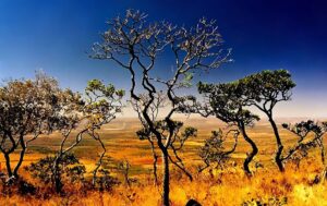
The Cerrado, one of Brazil's five major biomes, covers an extensive area of approximately 25% of the national territory. It extends over approximately 1.8 to 2 million square kilometers, covering several states, such as Goiás, Tocantins, Mato Grosso do Sul, Mato Grosso, Minas Gerais, Distrito Federal, Bahia, Maranhão, Piauí and parts of São Paulo. Furthermore, it is also possible to find small portions of cerrado in other states or in separate areas within other biomes, such as the Amazon Rainforest.
Considered the second largest plant formation in the country, right after the Amazon Forest, the Cerrado is characterized by great biological diversity. Furthermore, more than 40% of woody plant species and 50% of bees found in the Cerrado are endemic, that is, they are only found in this region.
The distribution and extent of the Cerrado are influenced by the tropical climate prevailing in the region. Precipitation varies from 750 to 2000 mm per year, with an average rainfall between 1100 and 1600 mm per year in most of the biome. It has two distinct climatic seasons: the dry season, which lasts approximately five months (from May to October), and the rainy season, which occurs for the remainder of the year (from October to May).
The Cerrado, in addition to its characteristic vegetation and terrestrial biodiversity, also houses a variety of aquatic environments essential for the balance of the biome. Among these environments, we find springs, ephemeral lagoons, swamps such as buritizais and veredas, as well as rivers and streams that form the main hydrographic basins in Brazil.
In the Cerrado core, the Paraná, Amazon and Eastern Brazil Domains are located. The Paraná Domain encompasses the headwaters of the Paranaíba River, its tributaries on the left bank and some tributaries on the right bank, such as the São Marcos River. The Eastern Domain of Brazil covers the sources of the São Francisco River, in the state of Minas Gerais, and tributaries on the left bank, such as the Paracatu River and the Urucuia River. The Amazon Domain covers the courses of the Upper and Middle Araguaia River and Tocantins River, in addition to the upper courses of some tributaries of the Xingu, Tapajós and Madeira rivers.
Furthermore, there are significant connections between the headwaters of the rivers that form the Tocantins, São Francisco and Parnaíba river basins, forming areas known as “Águas Amendmentadas”. These areas are located in the states of Goiás, Minas Gerais and the Federal District. These regions play a fundamental role in regulating water flow, contributing to the maintenance of aquatic ecosystems and the water supply in different regions of the country.
The Cerrado's aquatic environments are vital for wildlife and play a fundamental role in maintaining the biome's biodiversity and ecological cycles. They provide habitats for a variety of aquatic species such as fish, amphibians, reptiles and waterfowl. Furthermore, these environments are crucial for supplying water to the Cerrado vegetation and to the human communities that depend on the water resources in these regions.
However, like the rest of the Cerrado, aquatic environments face significant threats, including deforestation, water contamination, habitat fragmentation and dam construction. These human activities have negative impacts on water quality, aquatic biodiversity and the ecosystem services provided by these environments.
In the Cerrado biome, current statistics show a worrying situation regarding deforestation and loss of vegetation. Consolidated deforestation represents the largest proportion of outbreaks, totaling 101,502, which corresponds to 42.6% of the total. This means that a large area of land has already been converted to other uses, such as agriculture, livestock or urbanization.
Primary vegetation, which is the most preserved and natural form of the Cerrado, also suffered a high number of deforestation outbreaks, totaling 94,415, which represents 39.6% of the total. This data is alarming, as it indicates that even the most valuable and intact areas of the biome are being impacted by deforestation.
Recent deforestation, which are recently deforested areas, recorded 39,694 outbreaks, which is equivalent to 16.6% of the total. This suggests that pressure on the Cerrado continues, with the conversion of new areas for different human activities.
Other categories, such as “others” and secondary vegetation, also presented a significant number of deforestation hotspots, with 1,929 and 952 hotspots, respectively. Although they represent a smaller percentage of the total, they are still worrying, as they indicate the continued loss of natural areas and the reduction in the diversity and quality of Cerrado ecosystems.
The numbers show that Tocantins and Goiás lead the accumulated deforestation in the Cerrado, with deforested areas of 48,293.33 km² and 48,229.04 km², respectively. These values represent 16,08% and 16,06% of the total deforested, highlighting the pressure on these states in particular.
Other states also record significant levels of accumulated deforestation, such as Maranhão and Mato Grosso, with 45,595.89 km² and 45,167.64 km² deforested, corresponding to 15.18% and 15.04%, respectively. Minas Gerais and Bahia are also among the most affected states, with 41,409.34 km² and 24,984.72 km² deforested, representing 13,79% and 8,32% of the total, respectively.
These numbers are worrying, as they indicate a considerable loss of natural areas in the Cerrado, which has significant consequences for biodiversity, water resources and the region's ecological balance. Deforestation in these areas compromises the survival of unique plant and animal species, as well as contributing to the emission of greenhouse gases and the loss of vital ecosystem services.
The Cerrado biome covers a vast territorial extension in the Brazilian states, and conservation units play a crucial role in preserving this important ecosystem. However, the most recent statistical data reveals an alarming panorama regarding the accumulated deforestation in these protected areas.
Among the Cerrado conservation units, the state of Tocantins recorded the largest increase in accumulated deforestation, with a deforested area of 48,293.33 km², representing 16.08% of the total deforested. Next, we have Goiás, with 48,229.04 km² deforested (16.06%), and Maranhão, with 45,595.89 km² deforested (15.18%). These numbers reveal the magnitude of the challenge faced in protecting the Cerrado in these regions.
Other states that have high rates of accumulated deforestation are Mato Grosso, with 45,167.64 km² deforested (15.04%), and Minas Gerais, with 41,409.34 km² deforested (13.79%). These numbers reflect the constant pressure on conservation areas in these states, putting the Cerrado's biodiversity and natural resources at risk.
With regard to specific conservation units, the Ilha do Bananal/Cantão Environmental Protection Area is the one with the largest increase in accumulated deforestation, covering an area of 4,767.84 km², which represents 26.30% of total deforestation in the units of conservation of the Cerrado. In second place, we have the Rio Preto Environmental Protection Area, with 2,466.60 km² deforested (13.60%).
Other conservation units also suffer from accumulated deforestation, such as the Upaon-Açu/Miritiba/Alto Preguiças Environmental Protection Area, with 1,093.13 km² deforested (6.03%), and the Rio de Janeiro Basin Environmental Protection Area , with 997.05 km² deforested (5.50%). These numbers highlight the urgency of effective actions to halt deforestation in these protected areas and guarantee the conservation of the Cerrado.
Lungs of the Planet: The Vital Role of the Amazon Rainforest
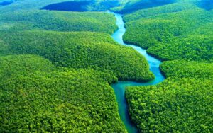
The Amazon Rainforest is the most famous and extensive biome in Brazil, covering almost half of its territory. Furthermore, this lush forest extends into parts of other neighboring countries, forming a unique and diverse ecosystem. Its natural wealth has attracted researchers from all over the world over the centuries, interested in unveiling its secrets and preserving its magnificence.
The Amazon covers nine Brazilian states – Acre, Amapá, Amazonas, Pará, Rondônia, Roraima, Tocantins, Mato Grosso and Maranhão, a true treasure of biodiversity. With its impressive 5 million square kilometers, it is the largest biome in Brazil and is home to an unparalleled wealth of wildlife and lush vegetation.
In addition to its impressive biodiversity and climate function, the Amazon Rainforest is also a home to millions of people, including indigenous communities. This region is home to the largest indigenous population in the country and has important cities, such as Belém and Manaus.
In the heart of the Amazon, we find a population of around 433 thousand indigenous people, whose cultures and traditions are intrinsically linked to this vast forest. Their lives and ancestral knowledge are fundamental to the preservation of this unique ecosystem.
The diversity of plants in the Amazon is simply stunning. With approximately 30,000 cataloged plant species, including majestic trees, colorful flowers and valuable medicinal plants, the Amazon rainforest is a true botanical paradise.
The fauna is also extraordinary. With an estimated 30 million animal species, the fauna of the Amazon is truly impressive. The region is home to 311 species of mammals, such as the jaguar, the pink dolphin and the sloth, which play crucial roles in the local ecology. Furthermore, there are more than 1,300 species of birds, such as the blue macaw, the toucan and the parrot, which fill the Amazonian skies with their colors and melodious songs. But most of the Amazon fauna is made up of insects, such as beetles, moths, ants and wasps, which play fundamental roles in local ecosystems.
Reptiles also play an important role in the Amazon ecosystem, with 350 different species, including alligators, turtles and snakes. Amphibians are also abundant, with 163 species of frogs, toads and tree frogs contributing to the complex web of life in the region.
Despite all this diversity, the Amazon faces significant threats. Around 152 plant species and 24 animal species are currently threatened with extinction.
In the Amazon rivers, we find an impressive aquatic wealth, with approximately 1,800 species of fish. These rivers are vital habitats for many species, including the Amazon manatee.
The plant diversity of the Amazon Rainforest is equally spectacular. Divided into three main categories, the terra firma, floodplain and igapó forests – they are home to giant trees such as the chestnut and kapok, considered the “queen of the forest”. In lower, periodically flooded areas, lower vegetation appears, such as bushes, vines, mosses and the memorable water lily. Orchids and bromeliads also beautify the landscape, providing a spectacle of colors and shapes.
Although the Amazon Forest has already been called the “lungs of the world”, studies show that oxygen production is balanced by the forest’s own consumption of carbon dioxide. However, its importance for climate regulation is unquestionable. The forest stores approximately a fifth of the planet's fresh water and plays a crucial role in cloud formation and rainfall distribution, directly influencing the climate in South America.
The soil of the Amazon rainforest is generally quite sandy. It has a thin layer of nutrients that is formed from the decomposition of leaves, fruits and dead animals. This layer is rich in humus, organic matter that is very important for some plant species in the region. In deforested areas, heavy rains “wash” the soil, carrying its nutrients. It's called the leaching process, which leaves Amazonian soils even poorer. Only 14% of the entire territory can be considered fertile for agriculture.
Unfortunately, the Amazon Forest faces major threats, such as deforestation and fires. Logging and agricultural expansion, mainly for cattle raising, have caused the loss of vast areas of forest and the extinction of several species.
Statistical data from 2023 indicates deforestation in the Legal Amazon, highlighting the extent of the problem in each state in the region. These statistics provide a clear view of the most affected areas and allow us to understand the severity of deforestation and its impacts on the forest and biodiversity.
The state of Pará leads the ranking with a deforested area of 49,561.45 km², representing 41.13% of the total deforested in the Legal Amazon. These impressive numbers highlight the urgency of action to combat deforestation in this region. Massive deforestation in Pará represents a significant threat to the tropical forest and its natural riches.
In second place, we have Mato Grosso, with 22,577.88 km² deforested, which corresponds to 18.73% of the total. This state, known for its agricultural activity, faces challenges related to the expansion of cultivation and pasture areas, which result in habitat loss and forest fragmentation.
Rondônia, occupying third place, records deforestation of 15,576.31 km² (12.92% of the total). This state has historically been affected by deforestation due to activities such as logging and land conversion for agricultural purposes. Deforestation in Rondônia highlights the need for effective measures to contain this destruction.
Amazonas, with a deforested area of 15,453.60 km² (12,82%), occupies fourth place in this sad ranking. Considered the largest state in the Legal Amazon, deforestation in this region has significant impacts on biodiversity and the ecosystem services provided by the forest, such as climate regulation and the maintenance of water resources.
The other states also present worrying numbers. Acre records 6,356.45 km² (5.27%); Maranhão, 6,175.60 km² (5.12%); Roraima, 3,657.82 km² (3.04%); Tocantins, 694.58 km² (0.58%); and Amapá, 460.09 km² (0.38%). Although deforested areas may vary in extent, they all contribute to biodiversity loss, climate change and other negative impacts.
According to data on deforestation – at municipal level – we have Altamira at the far end, with a deforested area of 6,127.36 km², representing a significant portion of the total deforested in the Legal Amazon. This municipality, located in the state of Pará, faces significant challenges in relation to deforestation due to activities such as the expansion of agriculture and the construction of infrastructure.
Next is São Félix do Xingu, also located in Pará, with a deforested area of 5,522.99 km². This municipality has historically been impacted by deforestation due to logging, agricultural expansion and extensive livestock farming.
Porto Velho, capital of Rondônia, occupies third place, with a deforested area of 4,833.14 km². The strategic location of this municipality, close to border areas and important transport routes, contributes to pressure on the tropical forest.
Lábrea, located in the state of Amazonas, records a deforested area of 3,701.31 km², occupying fourth position on the list. This municipality faces challenges related to illegal logging, land grabbing and unsustainable agricultural activities.
In fifth place, we have Novo Progresso, in Pará, with a deforested area of 2,814.46 km². This municipality also suffers from the advance of agriculture and the opening of new areas for cultivation and pasture.
The other municipalities also present worrying numbers in relation to deforestation, including Colniza, Novo Repartimento, Apuí, Pacajá, Itaituba, Portel, Nova Mamoré and Novo Aripuanã.
Regarding deforestation that occurred on indigenous lands in the Legal Amazon, Apyterewa is the most affected indigenous land, with a deforested area of 455.83 km², representing 11,45% of the total deforested on indigenous lands in the region. The destruction of this indigenous land, located in Pará, is worrying, as it directly affects the lives and livelihoods of the communities that live there.
Cachoeira Seca occupies second place, with a deforested area of 418.05 km², corresponding to 10,50% of deforestation on indigenous lands. This indigenous land, also located in Pará, faces serious challenges related to the invasion of illegal loggers and the advance of agriculture.
Ituna/Itatá, located in Pará, has use restrictions due to the presence of isolated indigenous groups. The FUNAI (National Indian Foundation) Ordinance prohibited the stay and entry of people who are not part of Funai's staff and people who are not indigenous. Those that do not fit into this group can be considered invasive, which requires even greater protection to guarantee their preservation. It has a deforested area of 238.24 km², representing 5,98% of total deforestation.
Other indigenous lands affected by deforestation include Maraiwatsede, Trincheira Bacaja, Yanomami, Awa, Kayapó, Alto Rio Guamá, Parque do Xingu, Munduruku, Alto Turiaçu and Bacurizinho. All of these indigenous lands face pressures resulting from the illegal exploitation of natural resources, land grabbing and invasions.
There was also deforestation in some of the Conservation Units (CUs) in the Legal Amazon, highlighting the most affected areas.
The Triunfo do Xingu Environmental Protection Area is the most affected UC, with an increase in accumulated deforestation of 4,069.92 km², representing 35,00% of the total deforestation in the UCs. This data is alarming, as this area is crucial for the protection of flora, fauna and natural resources present in the region.
The Jamanxim National Forest occupies second place, with accumulated deforestation of 1,134.62 km², corresponding to 9,76% of the total. This UC is known for its rich biodiversity and for housing threatened species, which highlights the urgency in strengthening their protection.
The Jaci-Paraná Extractive Reserve is in third place, with an increase in accumulated deforestation of 1,075.78 km², representing 9,25% of total deforestation. This UC plays an important role in promoting the sustainable use of natural resources by traditional communities living in the region.
Other UCs affected by deforestation include the Tapajós Environmental Protection Area, the Chico Mendes Extractive Reserve, the Altamira National Forest, the Tucuruí Lake Environmental Protection Area, the Guajará-Mirim State Park, the Terra do Meio Ecological Station , the Baixada Maranhense Environmental Protection Area, the Upaon-Açu / Miritiba / Alto Preguiças Environmental Protection Area, the Gurupi Biological Reserve and the Nascentes Serra do Cachimbo Biological Reserve.
Partnerships for Biodiversity Conservation in the Central-West of Brazil
The Central-West region of Brazil is home to rich biodiversity, with varied ecosystems ranging from the Pantanal to the Cerrado. These biomes are extremely important not only for the region, but also for the entire country and for the balance of the planet. However, this biodiversity is facing significant threats and therefore implementing conservation measures is urgent and necessary.
The Cerrado, considered the richest savannah in the world, is home to a great diversity of plant and animal species, many of which are endemic and found nowhere else. However, this biome is constantly being degraded due to the expansion of agriculture, livestock farming and disorderly urbanization. The conversion of Cerrado areas into agricultural land or pastures is resulting in the loss of natural habitats and the consequent decline in biodiversity.
The Pantanal, in turn, is one of the most important and exuberant ecosystems in the world, known for its rich species of plants, birds, fish and mammals. However, this biome also faces significant threats, especially due to deforestation, forest fires and river pollution. These problems are worsened by climate change, which affects rainfall and increases the risk of droughts and extreme floods.
One of the main initiatives of the Department of Ecosystems of the Ministry of the Environment (MMA) for the Pantanal is the GEF Terrestre Project, which aims to develop conservation, restoration and management strategies for biodiversity not only in the Pantanal, but also in the Caatinga and Pampa . This project, coordinated by the MMA, was implemented in May 2018 and has the support of the Inter-American Development Bank (IDB), being executed by the Brazilian Biodiversity Fund (FUNBIO). It is expected to end in May 2023.
However, even with this initiative underway, the Pantanal's riches remain threatened. Data from the National Institute for Space Research (INPE) reveal an alarming growth of 200% in fires in the region between 2019 and 2020. In 2021, the data indicates 90.68% of deforested area and in 2022, it decreased to 78.94%, however, still worrying . The Environmental Satellite Applications Laboratory (LASA) at the Federal University of Rio de Janeiro (UFRJ) found that the fires devastated approximately 29% of the biome's territory.
Created in 2015, in Patrocínio – MG, the Cerrado das Águas Consórcio aims to combine efforts to implement strategies that guarantee the provision of ecosystem services in order to achieve a productive system resilient to climate change. The strategies presented were regenerative coffee farming, which is based on the action of the soil covered at all times, diversity in the landscape, biological control and the use of macro and microbiological. It is important to point out that although there was a decrease in the deforested area from 2021 to 2022, the data still significantly points to a difference from 26,75% – 2021 – to 26,51%, 2022.
In Mato Grosso do Sul, Santa Luzia and Eldorado Environmental Preservation Units, based in Nova Alvorada do Sul and Rio Brilhante, respectively, are responsible for donating native plants from the cerrado. This year, the two plants delivered around 500 seedlings and 100 bags of seeds to local communities at important events such as Expocanas, in Nova Alvorada do Sul, and the 1st Ecological Fair in Deodápolis. In addition to the residents, the municipal nurseries were also given eight tons of filter cake, an organic compound from the sugar cane grinding process that has important properties in fertilizing vegetation.
During Arbor Day week, the plants' Environmental area teams scheduled lectures on the importance of environmental preservation for 5,800 elementary and high school students from 11 schools in Nova Alvorada do Sul and Deodápolis.
At the Goiás Complex, the Rio Claro, Morro Vermelho and Água Ouvida units, located in Caçu, Mineiros and Perolândia, respectively, planted and donated 2,600 seedlings to reinforce nurseries and recover springs. Many native species of the cerrado were directed to non-governmental organizations that promote the conservation of endangered animal species, such as the jaguar.
Brazil has adopted a series of measures and programs to protect and preserve the environment, especially in the Amazon region. Some of these actions stand out as important strategies for combating illegal deforestation, valuing nature conservation and promoting environmental sustainability.
One of these initiatives is Operation Verde Brasil 2, launched in May 2022. This operation aims to combat environmental crimes, fires and deforestation in the Legal Amazon. It has the participation of institutions such as the Federal Police, the Federal Highway Police, Ibama, ICMBio (Chico Mendes Institute for Biodiversity Conservation), among other environmental control and public safety bodies.
The Floresta + Program is another relevant action, aimed at valuing and compensating those who preserve and care for the Brazilian native forest. Using resources from the Green Climate Fund, the program pays for nature protection, conservation and recovery activities in the Legal Amazon. In this way, several land categories are covered, from private and permanent preservation areas to settlements, indigenous lands and conservation units.
Furthermore, Brazil seeks to stand out in the carbon credits market through the Floresta + Carbono program. This program aims to generate carbon credits from the conservation and recovery of native vegetation. Companies that are unable to reduce their carbon emissions can offset them by investing in projects to preserve and recover native forests.
To combat illegal deforestation, the Federal Government created the Executive Commission for Control of Illegal Deforestation in 2022. This commission is responsible for proposing plans and guidelines to prevent and control illegal deforestation, in addition to coordinating the implementation of the National Forest Recovery Policy. Native vegetation.
The National System for Controlling the Origin of Forest Products (Sinaflor +) was launched in 2022 to strengthen control and combat illegal deforestation in the Amazon. This initiative allows the origin of wood to be tracked, bringing more security to the timber sector and helping to prevent fraud.
The Adapta Brasil platform, developed by the Ministry of Science, Technology and Innovation in partnership with the National Institute for Space Research (Inpe), brings together indicators and impacts of climate change in Brazil. This tool assists the public sector in adopting protective measures and developing public policies to adapt to climate change.
Under this premise, the Oakpar Foundation develops the Biomas do Brasil Program, whose mission is to combat climate change and its impacts, promoting the preservation of the environment and mitigating the effects of global warming caused by human actions.
Its main objective is to disseminate the ecological, genetic, social, economic, scientific, educational, cultural, recreational and aesthetic values of biodiversity, promoting the conservation of remaining natural resources and areas of great importance to humanity.
It seeks to reinforce resilience and adaptation capacity to climate risks and natural disasters, in addition to promoting socio-environmental awareness and the defense and conservation of natural resources threatened by activities such as real estate speculation, fires, mineral extraction and predatory exploitation of fauna and flora.
Discover the Biomas do Brasil Program
The Brazilian Biomes Program will be implemented in preserved and/or impacted areas, with biological relevance and natural landscape value, in the six Brazilian biomes: Amazon Forest, Atlantic Forest, Cerrado, Pantanal, Pampa and Caatinga. Its focus is on the creation and maintenance of conservation units of full protection and sustainable use, especially environmental parks in the form of Private Natural Heritage Reserves (RPPNs). These areas will feature improvements and structures for conservation and public visitation, such as botanical spaces with artisanal items and seedlings of Brazilian flora species, and arboretums with nurseries, orchids, herbariums, butterfly gardens, trees, shrubs and ornamental, medicinal, edible and herbaceous plants . Therefore, preserving Brazil's biomes is protecting the essence of life in all its forms, ensuring a sustainable future for present and future generations.